


Parcours santé chanois

nicolasdresse
User

Length
4.8 km

Max alt
333 m

Uphill gradient
77 m
Km-Effort
5.9 km

Min alt
274 m

Downhill gradient
86 m
Boucle
Yes
Creation date :
2022-03-20 16:56:30.0
Updated on :
2022-03-20 18:13:43.54
1h16
Difficulty : Easy

FREE GPS app for hiking
 SityTrail
IGN / Geographical institutes
SityTrail Plus
The world is yours!
About
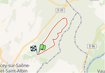
Trail Walking of 4.8 km to be discovered at Bourgogne-Franche-Comté, Haute-Saône, Scey-sur-Saône-et-Saint-Albin. This trail is proposed by nicolasdresse.
Positioning
Country:
France
Region :
Bourgogne-Franche-Comté
Department/Province :
Haute-Saône
Municipality :
Scey-sur-Saône-et-Saint-Albin
Location:
Unknown
Start:(Dec)
Start:(UTM)
724213 ; 5283829 (31T) N.
Comments