Trail Walking Saint-Symphorien - Chemin du Vent d'Ouest - Saint-Symphorien - Photo

Chemin du Vent d'Ouest - Saint-Symphorien

 tracegps
tracegps

User

© OpenStreetMap contributors
Length
Length
8.7 km
Max alt
Max alt
134 m
Uphill gradient
Uphill gradient
80 m
Km-Effort
Km-Effort  
9.8 km
Min alt
Min alt
83 m
Downhill gradient
Downhill gradient
81 m
Boucle
Boucle
Yes
Creation date :
2014-12-10 00:00:00.0
Updated on :
2014-12-10 00:00:00.0

(0 Reviews)

Walking
Walking
2h19
Difficulty : Medium

Scan this QR Code to open this trail in the SityTrail application

FREE GPS app for hiking

Logo SityTrail SityTrail

IGN / Geographical institutes

Download SityTrail from the App Store Download SityTrail from Google Play

Logo SityTrail SityTrail World

The world is yours!

Download SityTrail from the App Store Download SityTrail from Google Play Download SityTrail on Huawei AppGallery

About

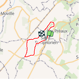
Trail Walking of 8.7 km to be discovered at Normandy, Eure, Saint-Symphorien. This trail is proposed by tracegps.

Description

Départ : grand parking près de l'église de Saint-Symphorien (autre départ possible à la mairie des Préaux) A voir sur le chemin: - L’abbaye des Préaux : un grand mur d’enceinte constitue le seul vestige encore visible de cet établissement religieux qui eut un grand rayonnement au Moyen-Age mais qui fut détruit après la Révolution. - Le paysage varié des champs ouverts sur le plateau au balcon arboré sur la vallée en passant par des coins de bocage préservé avec leurs haies champêtres et leurs maisons en colombage. - Les églises : romane du XIIe siècle aux Préaux (ancienne chapelle de l’abbaye) et au style plus composite à Saint-Symphorien avec son if millénaire

Elevation profile

Photos

Positioning

Country:
France
Region :
Normandy
Department/Province :
Eure
Municipality :
Saint-Symphorien
Location:
Unknown
Start:(UTM)
315908 ; 5465410 (31U) N.

Trails nearby

Trail Walking Saint-Siméon - St Simèon la chapelle St Frimint - Photo
Walking
Laurent53

Walking

Difficult
(1)
Saint-Siméon, Normandy, Eure, France
11.6 km | 14.5 km-effort
3h 8min
Yes
Trail Walking Saint-Siméon - Chemin des 4 Gués - Saint Siméon - Photo
Walking
tracegps

Walking

Medium
(1)
Saint-Siméon, Normandy, Eure, France
8.9 km | 11.1 km-effort
2h 30min
Yes
Trail Walking Tourville-sur-Pont-Audemer - Chemin de la Guinguette - Photo
Walking
bub27

Walking

Difficult
(1)
Tourville-sur-Pont-Audemer, Normandy, Eure, France
9.5 km | 13.2 km-effort
2h 47min
Yes
Trail Walking Saint-Siméon - Saint Siméon- Gués et Chapelle Saint Firmin - Photo
Walking
MichelRando7656

Walking

Difficult
(1)
Saint-Siméon, Normandy, Eure, France
12 km | 14.9 km-effort
3h 28min
Yes
Trail Mountain bike Saint-Symphorien - Chemin du Vent d'Ouest - Saint-Symphorien - Photo
Mountain bike
tracegps

Mountain bike

Easy
Saint-Symphorien, Normandy, Eure, France
8.7 km | 9.8 km-effort
1h 0min
Yes
Trail Walking Saint-Siméon - activity_st_simeon_2VOdFxXLOF174BcHu4EdDEVgPWR - Photo
Walking
doudet

Walking

Difficult
Saint-Siméon, Normandy, Eure, France
10.7 km | 13.7 km-effort
3h 6min
Yes
Trail Equestrian Épaignes - Chemin de la Barretterie - Epaignes - Photo
Equestrian
tracegps

Equestrian

Easy
Épaignes, Normandy, Eure, France
5.3 km | 5.7 km-effort
45min
Yes
Trail Mountain bike Épaignes - Chemin de la Barretterie - Epaignes - Photo
Mountain bike
tracegps

Mountain bike

Easy
Épaignes, Normandy, Eure, France
5.3 km | 5.7 km-effort
30min
Yes
Trail Walking Épaignes - Chemin de la Barretterie - Epaignes - Photo
Walking
tracegps

Walking

Easy
Épaignes, Normandy, Eure, France
5.3 km | 5.7 km-effort
1h 19min
Yes


Close
My subscriptions