Trail Walking Tévenon - hike14 - Photo

Optez pour le retour à la nature GUIDE+

© OpenStreetMap contributors
Length
Length
14.3 km
Max alt
Max alt
1589 m
Uphill gradient
Uphill gradient
575 m
Km-Effort
Km-Effort  
22 km
Min alt
Min alt
1068 m
Downhill gradient
Downhill gradient
727 m
Boucle
Boucle
No
Creation date :
2014-12-10 00:00:00.0
Updated on :
2014-12-10 00:00:00.0

(1 Reviews)

Walking
Walking
--
Difficulty : Unknown

Scan this QR Code to open this trail in the SityTrail application

FREE GPS app for hiking

Logo SityTrail SityTrail

IGN / Geographical institutes

Download SityTrail from the App Store Download SityTrail from Google Play

Logo SityTrail SityTrail Plus

The world is yours!

Download SityTrail from the App Store Download SityTrail from Google Play Download SityTrail on Huawei AppGallery

About

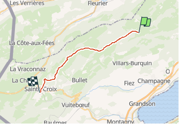
Trail Walking of 14.3 km to be discovered at Vaud, District du Jura-Nord vaudois, Tévenon. This trail is proposed by My Switzerland.

Elevation profile

Points of interest

Point of interest Tévenon - La Combaz - Photo
My Switzerland
TÉVENON 
Point of interest Bullet -  - Photo
My Switzerland
BULLET 
Point of interest Bullet -  - Photo
My Switzerland
BULLET 
Point of interest Sainte-Croix - Ste-Croix - Photo
My Switzerland
SAINTE-CROIX 

Positioning

Country:
Switzerland
Region :
Vaud
Department/Province :
District du Jura-Nord vaudois
Municipality :
Tévenon
Location:
Unknown
Start:(UTM)
319952 ; 5194046 (32T) N.

Comments

Please log in to post a review or rate the element


Close
My subscriptions