


Cabane Ourtiga

philou6351
User
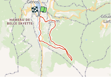

Length
13.7 km

Max alt
1619 m

Uphill gradient
714 m
Km-Effort
23 km

Min alt
965 m

Downhill gradient
714 m
Boucle
Yes
Creation date :
2022-03-22 08:04:10.92
Updated on :
2022-03-22 08:05:03.459
5h17
Difficulty : Very difficult

FREE GPS app for hiking
 SityTrail
IGN / Geographical institutes
SityTrail Plus
The world is yours!
About
Trail Walking of 13.7 km to be discovered at Occitania, Hautespyrenees, Loudenvielle. This trail is proposed by philou6351.
Positioning
Country:
France
Region :
Occitania
Department/Province :
Hautespyrenees
Municipality :
Loudenvielle
Location:
Loudenvielle
Start:(Dec)
Start:(UTM)
288120 ; 4741480 (31T) N.
Comments