


Cesson la Forêt 22/03/2022

robinier
User

Length
11.9 km

Max alt
89 m

Uphill gradient
109 m
Km-Effort
13.4 km

Min alt
36 m

Downhill gradient
109 m
Boucle
Yes
Creation date :
2022-03-22 07:54:27.0
Updated on :
2022-03-22 11:24:39.35
3h12
Difficulty : Easy

FREE GPS app for hiking
 SityTrail
IGN / Geographical institutes
SityTrail Plus
The world is yours!
About
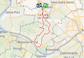
Trail Walking of 11.9 km to be discovered at Ile-de-France, Seine-et-Marne, Cesson. This trail is proposed by robinier.
Positioning
Country:
France
Region :
Ile-de-France
Department/Province :
Seine-et-Marne
Municipality :
Cesson
Location:
Unknown
Start:(Dec)
Start:(UTM)
470162 ; 5378509 (31U) N.
Comments