


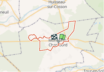
M'ont Près Chambord GS 2022

mimilolo
User

Length
13.8 km

Max alt
127 m

Uphill gradient
124 m
Km-Effort
15.5 km

Min alt
83 m

Downhill gradient
123 m
Boucle
Yes
Creation date :
2022-03-22 07:29:55.585
Updated on :
2022-03-22 12:57:00.471
3h13
Difficulty : Very easy

FREE GPS app for hiking
 SityTrail
IGN / Geographical institutes
SityTrail Plus
The world is yours!
About
Trail Walking of 13.8 km to be discovered at Centre-Loire Valley, Loir-et-Cher, Mont-près-Chambord. This trail is proposed by mimilolo.
Description
départ parking gymnase
Positioning
Country:
France
Region :
Centre-Loire Valley
Department/Province :
Loir-et-Cher
Municipality :
Mont-près-Chambord
Location:
Unknown
Start:(Dec)
Start:(UTM)
383833 ; 5268609 (31T) N.
Comments