Trail Walking Liestal - hike20 - Photo

Optez pour le retour à la nature GUIDE+
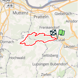
© OpenStreetMap contributors
Length
Length
17 km
Max alt
Max alt
762 m
Uphill gradient
Uphill gradient
579 m
Km-Effort
Km-Effort  
25 km
Min alt
Min alt
323 m
Downhill gradient
Downhill gradient
580 m
Boucle
Boucle
Yes
Creation date :
2014-12-10 00:00:00.0
Updated on :
2014-12-10 00:00:00.0

(2 Reviews)

Walking
Walking
--
Difficulty : Unknown

Scan this QR Code to open this trail in the SityTrail application

FREE GPS app for hiking

Logo SityTrail SityTrail

IGN / Geographical institutes

Download SityTrail from the App Store Download SityTrail from Google Play

Logo SityTrail SityTrail Plus

The world is yours!

Download SityTrail from the App Store Download SityTrail from Google Play Download SityTrail on Huawei AppGallery

About

Trail Walking of 17 km to be discovered at Basel-Landschaft, Bezirk Liestal, Liestal. This trail is proposed by My Switzerland.

Elevation profile

Points of interest

Point of interest Liestal - Liestal - Photo
My Switzerland
LIESTAL 
Point of interest Liestal -  - Photo
My Switzerland
LIESTAL 
Point of interest Gempen -  - Photo
My Switzerland
GEMPEN 
Point of interest Gempen -  - Photo
My Switzerland
GEMPEN 
Point of interest Liestal - Liestal - Photo
My Switzerland
LIESTAL 

Positioning

Country:
Switzerland
Region :
Basel-Landschaft
Department/Province :
Bezirk Liestal
Municipality :
Liestal
Location:
Unknown
Start:(UTM)
404458 ; 5259765 (32T) N.

Comments

Please log in to post a review or rate the element


Close
My subscriptions