Trail Walking Schwende - hike23 - Photo

Optez pour le retour à la nature GUIDE+
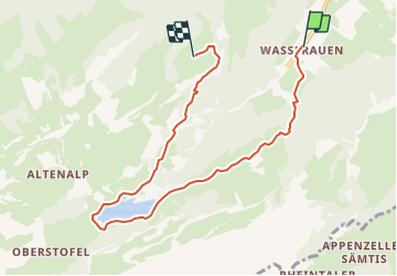
© OpenStreetMap contributors
Length
Length
7.2 km
Max alt
Max alt
1538 m
Uphill gradient
Uphill gradient
852 m
Km-Effort
Km-Effort  
16.3 km
Min alt
Min alt
866 m
Downhill gradient
Downhill gradient
191 m
Boucle
Boucle
No
Creation date :
2014-12-10 00:00:00.0
Updated on :
2014-12-10 00:00:00.0

(0 Reviews)

Walking
Walking
--
Difficulty : Unknown

Scan this QR Code to open this trail in the SityTrail application

FREE GPS app for hiking

Logo SityTrail SityTrail

IGN / Geographical institutes

Download SityTrail from the App Store Download SityTrail from Google Play

Logo SityTrail SityTrail Plus

The world is yours!

Download SityTrail from the App Store Download SityTrail from Google Play Download SityTrail on Huawei AppGallery

About

Trail Walking of 7.2 km to be discovered at Appenzell Innerrhoden, Unknown, Schwende. This trail is proposed by My Switzerland.

Elevation profile

Points of interest

Point of interest Schwende - Wasserauen - Photo
My Switzerland
SCHWENDE 
Point of interest Schwende -  - Photo
My Switzerland
SCHWENDE 
Point of interest Schwende -  - Photo
My Switzerland
SCHWENDE 
Point of interest Schwende -  - Photo
My Switzerland
SCHWENDE 
Point of interest Schwende - Ebenalp - Photo
My Switzerland
SCHWENDE 

Positioning

Country:
Switzerland
Region :
Appenzell Innerrhoden
Department/Province :
Unknown
Municipality :
Schwende
Location:
Unknown
Start:(UTM)
532396 ; 5237004 (32T) N.


Close
My subscriptions