Trail Walking Ébreuil - Le chemin des renards 🦊 2.0 - Photo

Le chemin des renards 🦊 2.0

 Gegetop
Gegetop

User

© OpenStreetMap contributors
Length
Length
14 km
Max alt
Max alt
473 m
Uphill gradient
Uphill gradient
300 m
Km-Effort
Km-Effort  
18 km
Min alt
Min alt
303 m
Downhill gradient
Downhill gradient
301 m
Boucle
Boucle
Yes
Creation date :
2022-03-23 10:55:32.922
Updated on :
2022-03-23 14:48:13.891

(0 Reviews)

Walking
Walking
3h30
Difficulty : Medium
Nordic walking
Nordic walking
3h11
Difficulty : Easy

Scan this QR Code to open this trail in the SityTrail application

FREE GPS app for hiking

Logo SityTrail SityTrail

IGN / Geographical institutes

Download SityTrail from the App Store Download SityTrail from Google Play

Logo SityTrail SityTrail World

The world is yours!

Download SityTrail from the App Store Download SityTrail from Google Play Download SityTrail on Huawei AppGallery

About

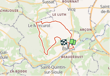
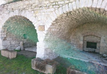
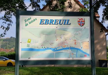
Trail Walking of 14 km to be discovered at Auvergne-Rhône-Alpes, Allier, Ébreuil. This trail is proposed by Gegetop.

Description

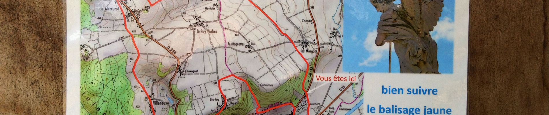
Nouveau circuit un peu plus court que le précédent.

Elevation profile

Photos

Positioning

Country:
France
Region :
Auvergne-Rhône-Alpes
Department/Province :
Allier
Municipality :
Ébreuil
Location:
Unknown
Start:(UTM)
506819 ; 5106888 (31T) N.

Trails nearby

Trail On foot Marcillat - Tour de Mathas - Photo
On foot
PRO

On foot

Easy
Marcillat, Auvergne-Rhône-Alpes, Puy-de-Dôme, France
13.4 km | 17.9 km-effort
4h 3min
Yes
Trail Walking Saint-Quintin-sur-Sioule - St_Quintin_Source_Charponne - Photo
Walking
GUIDE
jagarnier

Walking

Medium
Saint-Quintin-sur-Sioule, Auvergne-Rhône-Alpes, Puy-de-Dôme, France
12.9 km | 16.6 km-effort
3h 45min
Yes
Trail Walking Ébreuil - Ebreuil. Chemin des renards 🦊  - Photo
Walking
Gegetop

Walking

Medium
Ébreuil, Auvergne-Rhône-Alpes, Allier, France
16.9 km | 21 km-effort
3h 54min
Yes
Trail Walking Ébreuil - Ebreuil - Photo
Walking
guy63

Walking

Medium
Ébreuil, Auvergne-Rhône-Alpes, Allier, France
8.6 km | 9.2 km-effort
3h 14min
Yes
Trail Walking Ébreuil - Enbreuil les 2 ponts - Photo
Walking
jipelaire

Walking

Very difficult
Ébreuil, Auvergne-Rhône-Alpes, Allier, France
15.7 km | 19.4 km-effort
3h 22min
Yes
Trail Walking Saint-Bonnet-de-Rochefort - Randonnée organisée  - Photo
Walking
Vincent Bicard

Walking

Medium
Saint-Bonnet-de-Rochefort, Auvergne-Rhône-Alpes, Allier, France
6.1 km | 7 km-effort
1h 40min
Yes
Trail Mountain bike Ébreuil - Ebreuil Chantel Guyon - Photo
Mountain bike
Carnzu

Mountain bike

Very difficult
Ébreuil, Auvergne-Rhône-Alpes, Allier, France
38 km | 46 km-effort
4h 18min
No
Trail Walking Gannat - Peyrolles - Photo
Walking
jeriom

Walking

Easy
Gannat, Auvergne-Rhône-Alpes, Allier, France
9.1 km | 12.3 km-effort
2h 47min
Yes
Trail Electric bike Ébreuil - Laliz - Photo
Electric bike
NEMRUT

Electric bike

Easy
Ébreuil, Auvergne-Rhône-Alpes, Allier, France
25 km | 30 km-effort
1h 30min
Yes


Close
My subscriptions