Trail Walking Canaples - Le Montant Blanc - Canaples - Photo

Le Montant Blanc - Canaples

 tracegps
tracegps

User

© OpenStreetMap contributors
Length
Length
15.3 km
Max alt
Max alt
152 m
Uphill gradient
Uphill gradient
250 m
Km-Effort
Km-Effort  
18.7 km
Min alt
Min alt
46 m
Downhill gradient
Downhill gradient
250 m
Boucle
Boucle
Yes
Creation date :
2014-12-10 00:00:00.0
Updated on :
2014-12-10 00:00:00.0

(0 Reviews)

Walking
Walking
3h30
Difficulty : Difficult

Scan this QR Code to open this trail in the SityTrail application

FREE GPS app for hiking

Logo SityTrail SityTrail

IGN / Geographical institutes

Download SityTrail from the App Store Download SityTrail from Google Play

Logo SityTrail SityTrail World

The world is yours!

Download SityTrail from the App Store Download SityTrail from Google Play Download SityTrail on Huawei AppGallery

About

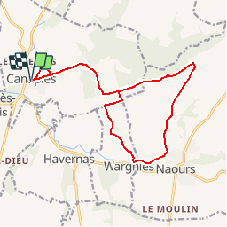
Trail Walking of 15.3 km to be discovered at Hauts-de-France, Somme, Canaples. This trail is proposed by tracegps.

Description

Circuit vallonné à partir de Canaples. Balisage jaune ancien, voir même inexistant. Vaut mieux se fier à sa carte IGN et à un bon GPS. Passe par Naours avec la possibilité d'aller voir les muches et les moulins à condition de sortir du circuit. Un peu de chemins goudronnés...

Elevation profile

Photos

Positioning

Country:
France
Region :
Hauts-de-France
Department/Province :
Somme
Municipality :
Canaples
Location:
Unknown
Start:(UTM)
444090 ; 5545150 (31U) N.

Trails nearby

Trail Walking Naours - le tour des éoliennes de naours - Photo
Walking
GebleuxGaetan

Walking

Very easy
Naours, Hauts-de-France, Somme, France
7.5 km | 8.5 km-effort
1h 34min
No
Trail Walking Canaples - Canaples - Photo
Walking
jpblimond

Walking

Medium
Canaples, Hauts-de-France, Somme, France
16.1 km | 19.2 km-effort
3h 57min
Yes
Trail Walking Naours - Dans la campagne près des muches - Photo
Walking
tracegps

Walking

Easy
Naours, Hauts-de-France, Somme, France
3.9 km | 4.9 km-effort
1h 19min
Yes
Trail Walking Halloy-lès-Pernois - Circuit du bois des dames - Photo
Walking
tracegps

Walking

Medium
Halloy-lès-Pernois, Hauts-de-France, Somme, France
12 km | 13.7 km-effort
4h 0min
Yes
Trail On foot Wargnies - Dans la Campagne près des Muches - Photo
On foot
PRO

On foot

Easy
Wargnies, Hauts-de-France, Somme, France
3.8 km | 4.8 km-effort
1h 5min
Yes
Trail Other activity Canaples - Picardie - Ligne 322 - Canaples - Longroy - Gamaches par Longpré - Photo
Other activity
mich54

Other activity

Very easy
Canaples, Hauts-de-France, Somme, France
57 km | 62 km-effort
5min
No
Trail Cycle Naours - Vélo sur route - Photo
Cycle
GebleuxGaetan

Cycle

Medium
Naours, Hauts-de-France, Somme, France
79 km | 87 km-effort
2h 55min
Yes
Trail sport Pernois -  - Photo
sport
club de la bresle

sport

Very easy
Pernois, Hauts-de-France, Somme, France
87 km | 103 km-effort
Unknown
No
Trail Mountain bike Vignacourt - VTT Vignacourt  - Photo
Mountain bike
docfil

Mountain bike

Medium
Vignacourt, Hauts-de-France, Somme, France
19.3 km | 22 km-effort
1h 25min
Yes


Close
My subscriptions