


trou de la jarre

ninia
User
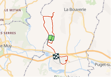

Length
12.2 km

Max alt
92 m

Uphill gradient
121 m
Km-Effort
13.9 km

Min alt
9 m

Downhill gradient
156 m
Boucle
No
Creation date :
2022-03-24 07:37:49.51
Updated on :
2022-03-24 11:03:34.138
3h25
Difficulty : Very easy

FREE GPS app for hiking
 SityTrail
IGN / Geographical institutes
SityTrail Plus
The world is yours!
About
Trail Walking of 12.2 km to be discovered at Provence-Alpes-Côte d'Azur, Var, Roquebrune-sur-Argens. This trail is proposed by ninia.
Positioning
Country:
France
Region :
Provence-Alpes-Côte d'Azur
Department/Province :
Var
Municipality :
Roquebrune-sur-Argens
Location:
Unknown
Start:(Dec)
Start:(UTM)
306952 ; 4816013 (32T) N.
Comments