Trail Walking Adliswil - mtb01 - Photo

Optez pour le retour à la nature GUIDE+
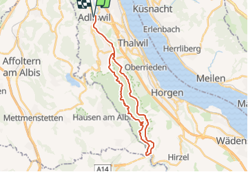
© OpenStreetMap contributors
Length
Length
29 km
Max alt
Max alt
700 m
Uphill gradient
Uphill gradient
635 m
Km-Effort
Km-Effort  
38 km
Min alt
Min alt
445 m
Downhill gradient
Downhill gradient
634 m
Boucle
Boucle
Yes
Creation date :
2014-12-10 00:00:00.0
Updated on :
2014-12-10 00:00:00.0

(0 Reviews)

Walking
Walking
--
Difficulty : Unknown

Scan this QR Code to open this trail in the SityTrail application

FREE GPS app for hiking

Logo SityTrail SityTrail

IGN / Geographical institutes

Download SityTrail from the App Store Download SityTrail from Google Play

Logo SityTrail SityTrail Plus

The world is yours!

Download SityTrail from the App Store Download SityTrail from Google Play Download SityTrail on Huawei AppGallery

About

Trail Walking of 29 km to be discovered at Zurich, Bezirk Horgen, Adliswil. This trail is proposed by My Switzerland.

Elevation profile

Points of interest

Point of interest Adliswil - Adliswil - Photo
My Switzerland
ADLISWIL 
Point of interest Horgen -  - Photo
My Switzerland
HORGEN 
Point of interest Langnau am Albis -  - Photo
My Switzerland
LANGNAU AM ALBIS 
Point of interest Adliswil - Adliswil - Photo
My Switzerland
ADLISWIL 

Positioning

Country:
Switzerland
Region :
Zurich
Department/Province :
Bezirk Horgen
Municipality :
Adliswil
Location:
Unknown
Start:(UTM)
464060 ; 5239994 (32T) N.


Close
My subscriptions