


garonette

py.jeannot@free.fr
User
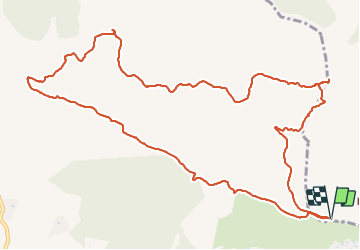

Length
14.9 km

Max alt
343 m

Uphill gradient
462 m
Km-Effort
21 km

Min alt
15 m

Downhill gradient
460 m
Boucle
Yes
Creation date :
2022-03-25 08:22:53.256
Updated on :
2022-03-25 16:04:07.772
5h12
Difficulty : Very difficult

FREE GPS app for hiking
 SityTrail
IGN / Geographical institutes
SityTrail Plus
The world is yours!
About
Trail Walking of 14.9 km to be discovered at Provence-Alpes-Côte d'Azur, Var, Roquebrune-sur-Argens. This trail is proposed by py.jeannot@free.fr.
Positioning
Country:
France
Region :
Provence-Alpes-Côte d'Azur
Department/Province :
Var
Municipality :
Roquebrune-sur-Argens
Location:
Unknown
Start:(Dec)
Start:(UTM)
310678 ; 4801625 (32T) N.
Comments