


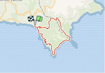
Lardier-Taillat par la Croix-Valmer

bernir
User

Length
15.1 km

Max alt
163 m

Uphill gradient
412 m
Km-Effort
21 km

Min alt
0 m

Downhill gradient
413 m
Boucle
Yes
Creation date :
2022-03-25 08:11:12.384
Updated on :
2022-03-26 12:52:11.604
6h28
Difficulty : Medium

FREE GPS app for hiking
 SityTrail
IGN / Geographical institutes
SityTrail Plus
The world is yours!
About
Trail Walking of 15.1 km to be discovered at Provence-Alpes-Côte d'Azur, Var, La Croix-Valmer. This trail is proposed by bernir.
Photos


Positioning
Country:
France
Region :
Provence-Alpes-Côte d'Azur
Department/Province :
Var
Municipality :
La Croix-Valmer
Location:
Unknown
Start:(Dec)
Start:(UTM)
304882 ; 4784234 (32T) N.
Comments