


Borrys-Sadaillan - Reveyrolle

Berpav
User
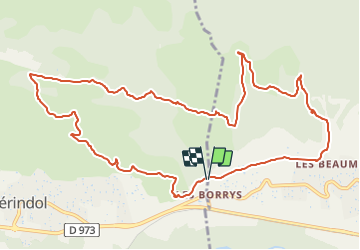

Length
13.4 km

Max alt
336 m

Uphill gradient
403 m
Km-Effort
18.8 km

Min alt
144 m

Downhill gradient
402 m
Boucle
Yes
Creation date :
2022-03-26 16:37:50.706
Updated on :
2022-03-26 16:43:16.173
4h16
Difficulty : Difficult

FREE GPS app for hiking
 SityTrail
IGN / Geographical institutes
SityTrail Plus
The world is yours!
About
Trail Walking of 13.4 km to be discovered at Provence-Alpes-Côte d'Azur, Vaucluse, Puget. This trail is proposed by Berpav.
Positioning
Country:
France
Region :
Provence-Alpes-Côte d'Azur
Department/Province :
Vaucluse
Municipality :
Puget
Location:
Unknown
Start:(Dec)
Start:(UTM)
679960 ; 4847491 (31T) N.
Comments
belle rando