


theillay apatinette

lecmic
User
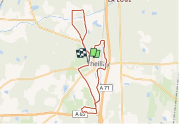

Length
17.2 km

Max alt
149 m

Uphill gradient
124 m
Km-Effort
18.9 km

Min alt
102 m

Downhill gradient
125 m
Boucle
Yes
Creation date :
2022-03-27 05:31:55.088
Updated on :
2022-03-27 08:20:41.871
2h43
Difficulty : Easy

FREE GPS app for hiking
 SityTrail
IGN / Geographical institutes
SityTrail Plus
The world is yours!
About
Trail Walking of 17.2 km to be discovered at Centre-Loire Valley, Loir-et-Cher, Theillay. This trail is proposed by lecmic.
Description
rando familiale
Positioning
Country:
France
Region :
Centre-Loire Valley
Department/Province :
Loir-et-Cher
Municipality :
Theillay
Location:
Unknown
Start:(Dec)
Start:(UTM)
427086 ; 5240451 (31T) N.
Comments