


Etang de Moras

Ardeiserois
User
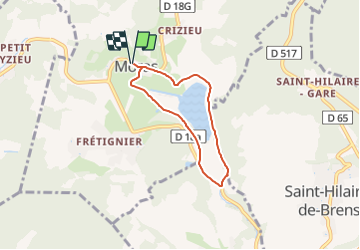

Length
5.1 km

Max alt
355 m

Uphill gradient
92 m
Km-Effort
6.3 km

Min alt
305 m

Downhill gradient
92 m
Boucle
Yes
Creation date :
2022-03-27 12:06:18.424
Updated on :
2022-03-27 12:06:55.022
1h26
Difficulty : Medium

FREE GPS app for hiking
 SityTrail
IGN / Geographical institutes
SityTrail Plus
The world is yours!
About
Trail Walking of 5.1 km to be discovered at Auvergne-Rhône-Alpes, Isère, Moras. This trail is proposed by Ardeiserois.
Positioning
Country:
France
Region :
Auvergne-Rhône-Alpes
Department/Province :
Isère
Municipality :
Moras
Location:
Unknown
Start:(Dec)
Start:(UTM)
675747 ; 5061869 (31T) N.
Comments