


ROCHE DES BRUYERES

surceneux
User
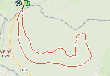

Length
5.7 km

Max alt
971 m

Uphill gradient
190 m
Km-Effort
8.2 km

Min alt
801 m

Downhill gradient
180 m
Boucle
Yes
Creation date :
2022-03-27 12:39:38.249
Updated on :
2022-03-27 14:25:20.009
1h15
Difficulty : Very easy

FREE GPS app for hiking
 SityTrail
IGN / Geographical institutes
SityTrail Plus
The world is yours!
About
Trail Walking of 5.7 km to be discovered at Grand Est, Vosges, Xonrupt-Longemer. This trail is proposed by surceneux.
Description
MARTIMPRE COL BEHEUILLE GILET RECT VERT MARTINPRE
Positioning
Country:
France
Region :
Grand Est
Department/Province :
Vosges
Municipality :
Xonrupt-Longemer
Location:
Unknown
Start:(Dec)
Start:(UTM)
344032 ; 5329339 (32U) N.
Comments