


Félines Termenes

Ada11
User GUIDE
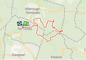

Length
19.1 km

Max alt
628 m

Uphill gradient
619 m
Km-Effort
27 km

Min alt
329 m

Downhill gradient
620 m
Boucle
Yes
Creation date :
2022-03-27 07:09:50.48
Updated on :
2022-03-27 14:28:36.805
4h37
Difficulty : Medium

FREE GPS app for hiking
 SityTrail
IGN / Geographical institutes
SityTrail Plus
The world is yours!
About
Trail Walking of 19.1 km to be discovered at Occitania, Aude, Félines-Termenès. This trail is proposed by Ada11.
Description
Un bout de tracé manquant au milieu, après le pique-nique.
Positioning
Country:
France
Region :
Occitania
Department/Province :
Aude
Municipality :
Félines-Termenès
Location:
Unknown
Start:(Dec)
Start:(UTM)
468420 ; 4759459 (31T) N.
Comments