Trail Walking Génissieux - Genissieux - Photo
 meillon
meillon

User

© OpenStreetMap contributors
Length
Length
8 km
Max alt
Max alt
298 m
Uphill gradient
Uphill gradient
210 m
Km-Effort
Km-Effort  
10.8 km
Min alt
Min alt
186 m
Downhill gradient
Downhill gradient
210 m
Boucle
Boucle
Yes
Creation date :
2022-03-27 13:06:55.193
Updated on :
2022-03-27 15:33:46.792

(1 Reviews)

Walking
Walking
2h26
Difficulty : Easy

Scan this QR Code to open this trail in the SityTrail application

FREE GPS app for hiking

Logo SityTrail SityTrail

IGN / Geographical institutes

Download SityTrail from the App Store Download SityTrail from Google Play

Logo SityTrail SityTrail World

The world is yours!

Download SityTrail from the App Store Download SityTrail from Google Play Download SityTrail on Huawei AppGallery

About

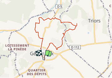
Trail Walking of 8 km to be discovered at Auvergne-Rhône-Alpes, Drôme, Génissieux. This trail is proposed by meillon.

Description

Tour du village, vues sur la région plaine de Romans vercors

Elevation profile

Positioning

Country:
France
Region :
Auvergne-Rhône-Alpes
Department/Province :
Drôme
Municipality :
Génissieux
Location:
Unknown
Start:(UTM)
664286 ; 4994195 (31T) N.

Comments

Please log in to post a review or rate the element


Beaux points de vue


Trails nearby

Trail Road bike Romans-sur-Isère - Romans saint Nazaire  - Photo
Road bike
meillon

Road bike

Very easy
(1)
Romans-sur-Isère, Auvergne-Rhône-Alpes, Drôme, France
47 km | 53 km-effort
3h 31min
Yes
Trail Walking Geyssans - Geyssans - Photo
Walking
OscarMa

Walking

Very easy
(3)
Geyssans, Auvergne-Rhône-Alpes, Drôme, France
8 km | 10 km-effort
2h 8min
Yes
Trail Walking Romans-sur-Isère - UP20240307Romans - Photo
Walking
Havani

Walking

Medium
Romans-sur-Isère, Auvergne-Rhône-Alpes, Drôme, France
8.4 km | 9.9 km-effort
2h 7min
Yes
Trail Walking Châtillon-Saint-Jean - 2022-12-04_22h50m01_chapelle_des_gillons_et_la_joyeuse - Photo
Walking
blueslover

Walking

Difficult
(1)
Châtillon-Saint-Jean, Auvergne-Rhône-Alpes, Drôme, France
10.1 km | 13.1 km-effort
2h 58min
Yes
Trail Walking Peyrins - peyrins - Photo
Walking
CathyBB26

Walking

Very easy
(1)
Peyrins, Auvergne-Rhône-Alpes, Drôme, France
8.4 km | 11.1 km-effort
2h 53min
Yes
Trail Road bike Bourg-de-Péage - combovin - Photo
Road bike
bernadette revoux

Road bike

Easy
Bourg-de-Péage, Auvergne-Rhône-Alpes, Drôme, France
55 km | 61 km-effort
4h 57min
Yes
Trail Walking Bourg-de-Péage - promenade avec Alice  - Photo
Walking
bernadette revoux

Walking

Very easy
Bourg-de-Péage, Auvergne-Rhône-Alpes, Drôme, France
4.9 km | 5.5 km-effort
1h 20min
Yes
Trail Walking Bourg-de-Péage - parc Mitterrand bellevue bord de l'Isère  - Photo
Walking
bernadette revoux

Walking

Very easy
Bourg-de-Péage, Auvergne-Rhône-Alpes, Drôme, France
4.3 km | 4.8 km-effort
59min
Yes
Trail Walking Peyrins - Les coteaux de Mours St Eusebe - Photo
Walking
bouviak

Walking

Very easy
(3)
Peyrins, Auvergne-Rhône-Alpes, Drôme, France
5.2 km | 6.5 km-effort
58min
Yes


Close
My subscriptions