


F26 Romeyer Chabrinel Faisan Econdus

ageo
User
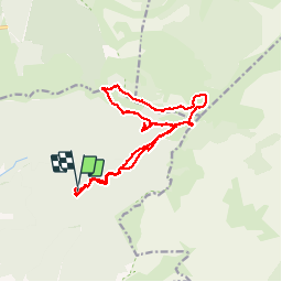

Length
18.6 km

Max alt
1724 m

Uphill gradient
1152 m
Km-Effort
34 km

Min alt
993 m

Downhill gradient
1171 m
Boucle
Yes
Creation date :
2017-06-06 00:00:00.0
Updated on :
2017-06-06 00:00:00.0
6h39
Difficulty : Medium

FREE GPS app for hiking
 SityTrail
IGN / Geographical institutes
SityTrail Plus
The world is yours!
About
Trail Walking of 18.6 km to be discovered at Auvergne-Rhône-Alpes, Drôme, Romeyer. This trail is proposed by ageo.
Description
LCV. Ne pas faire le détour vers Serre Reynier.
Positioning
Country:
France
Region :
Auvergne-Rhône-Alpes
Department/Province :
Drôme
Municipality :
Romeyer
Location:
Unknown
Start:(Dec)
Start:(UTM)
693436 ; 4964325 (31T) N.
Comments