


22 03 29 Autour de Rougemont le château

jmbilger
User
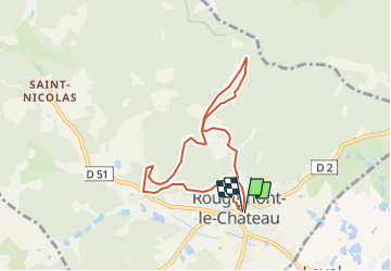

Length
6.9 km

Max alt
747 m

Uphill gradient
350 m
Km-Effort
11.6 km

Min alt
445 m

Downhill gradient
354 m
Boucle
Yes
Creation date :
2022-03-28 10:58:10.0
Updated on :
2022-03-28 10:58:11.896
2h37
Difficulty : Medium

FREE GPS app for hiking
 SityTrail
IGN / Geographical institutes
SityTrail Plus
The world is yours!
About
Trail Walking of 6.9 km to be discovered at Bourgogne-Franche-Comté, Territoire-de-Belfort, Rougemont-le-Château. This trail is proposed by jmbilger.
Positioning
Country:
France
Region :
Bourgogne-Franche-Comté
Department/Province :
Territoire-de-Belfort
Municipality :
Rougemont-le-Château
Location:
Unknown
Start:(Dec)
Start:(UTM)
347706 ; 5288905 (32T) N.
Comments