


st malo dinard

andrechauvin
User
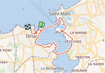

Length
17.6 km

Max alt
40 m

Uphill gradient
234 m
Km-Effort
21 km

Min alt
0 m

Downhill gradient
228 m
Boucle
No
Creation date :
2022-03-25 08:31:46.471
Updated on :
2022-03-28 14:16:00.594
5h16
Difficulty : Medium

FREE GPS app for hiking
 SityTrail
IGN / Geographical institutes
SityTrail Plus
The world is yours!
About
Trail Walking of 17.6 km to be discovered at Brittany, Ille-et-Vilaine, Dinard. This trail is proposed by andrechauvin.
Description
bord de mer
Positioning
Country:
France
Region :
Brittany
Department/Province :
Ille-et-Vilaine
Municipality :
Dinard
Location:
Unknown
Start:(Dec)
Start:(UTM)
569835 ; 5387402 (30U) N.
Comments