Trail Walking La Roche-en-Ardenne - Amazfit Watch - Photo
© OpenStreetMap contributors
Length
Length
27 km
Max alt
Max alt
397 m
Uphill gradient
Uphill gradient
568 m
Km-Effort
Km-Effort  
34 km
Min alt
Min alt
233 m
Downhill gradient
Downhill gradient
571 m
Boucle
Boucle
Yes
Creation date :
2022-03-28 16:42:27.694
Updated on :
2022-03-28 17:00:09.327

(0 Reviews)

Walking
Walking
3h30
Difficulty : Difficult
Canoe - kayak
Canoe - kayak
2h30
Difficulty : Very easy

Scan this QR Code to open this trail in the SityTrail application

FREE GPS app for hiking

Logo SityTrail SityTrail

IGN / Geographical institutes

Download SityTrail from the App Store Download SityTrail from Google Play

Logo SityTrail SityTrail Plus

The world is yours!

Download SityTrail from the App Store Download SityTrail from Google Play Download SityTrail on Huawei AppGallery

About

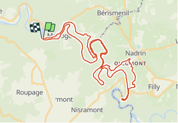
Trail Walking of 27 km to be discovered at Wallonia, Luxembourg, La Roche-en-Ardenne. This trail is proposed by dimitridt.

Description

Départ à pied de l'embarcadère de Maboge, rando de 3h30 jusqu'à l'embarcadère de Bressol. Gonflage du packraft, mise à l'eau et descente de 2h30 pour retourner au point de départ. Durée totale 7h00 avec les pauses et le gonflage du packraft.

Elevation profile

Positioning

Country:
Belgium
Region :
Wallonia
Department/Province :
Luxembourg
Municipality :
La Roche-en-Ardenne
Location:
Unknown
Start:(UTM)
686872 ; 5560528 (31U) N.


Close
My subscriptions