


petit tour avec PHIL

bernardcornu
User

Length
29 km

Max alt
691 m

Uphill gradient
774 m
Km-Effort
40 km

Min alt
406 m

Downhill gradient
781 m
Boucle
Yes
Creation date :
2022-03-29 08:04:23.708
Updated on :
2022-03-29 11:19:35.722
2h21
Difficulty : Medium

FREE GPS app for hiking
 SityTrail
IGN / Geographical institutes
SityTrail Plus
The world is yours!
About
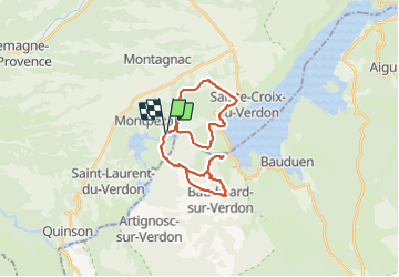
Trail Mountain bike of 29 km to be discovered at Provence-Alpes-Côte d'Azur, Alpes-de-Haute-Provence, Montagnac-Montpezat. This trail is proposed by bernardcornu.
Positioning
Country:
France
Region :
Provence-Alpes-Côte d'Azur
Department/Province :
Alpes-de-Haute-Provence
Municipality :
Montagnac-Montpezat
Location:
Montpezat
Start:(Dec)
Start:(UTM)
266629 ; 4847684 (32T) N.
Comments