


2022-03-30_18h36m19_tracedetrail_119756

jpb83
User
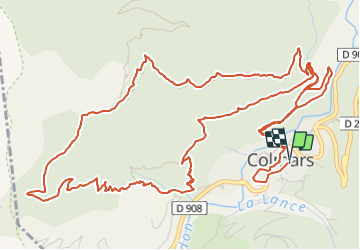

Length
10 km

Max alt
1663 m

Uphill gradient
596 m
Km-Effort
17.9 km

Min alt
1243 m

Downhill gradient
598 m
Boucle
Yes
Creation date :
2022-03-30 16:36:20.154
Updated on :
2022-03-30 19:55:23.493
1h30
Difficulty : Difficult

FREE GPS app for hiking
 SityTrail
IGN / Geographical institutes
SityTrail Plus
The world is yours!
About
Trail Trail of 10 km to be discovered at Provence-Alpes-Côte d'Azur, Alpes-de-Haute-Provence, Colmars. This trail is proposed by jpb83.
Positioning
Country:
France
Region :
Provence-Alpes-Côte d'Azur
Department/Province :
Alpes-de-Haute-Provence
Municipality :
Colmars
Location:
Unknown
Start:(Dec)
Start:(UTM)
310387 ; 4894737 (32T) N.
Comments