


Madère : vers le Pico Ruevo sommet de l'île

Bart2015
User


2h05
Difficulty : Medium

FREE GPS app for hiking
 SityTrail
IGN / Geographical institutes
SityTrail Plus
The world is yours!
About
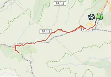
Trail Walking of 5.9 km to be discovered at Madeira, Unknown, Ilha. This trail is proposed by Bart2015.
Description
Randonnée très bien décrite dans le Rother Madère - n°33.
Randonnée cool pour atteindre facilement le sommet de l'île en empruntant un chemin pavé depuis le parking à l'Archada do Teixeira. Possibilité d'une halte à la Casa de Abrigo qui est aussi le départ d'autres randos : Pico do Ariero ou le Col d'Encumeada ...
Bonne rando ...
Photos


21 photos in total. Please click on a photo to see them all in the gallery.
Positioning
Comments