


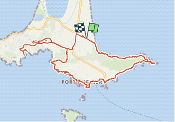
Giens port du Niel/cap de l'Esterel

bernir
User

Length
13.9 km

Max alt
57 m

Uphill gradient
228 m
Km-Effort
17 km

Min alt
0 m

Downhill gradient
229 m
Boucle
Yes
Creation date :
2022-04-01 07:15:44.049
Updated on :
2022-05-05 22:48:46.242
8h05
Difficulty : Medium

FREE GPS app for hiking
 SityTrail
IGN / Geographical institutes
SityTrail Plus
The world is yours!
About
Trail Walking of 13.9 km to be discovered at Provence-Alpes-Côte d'Azur, Var, Hyères. This trail is proposed by bernir.
Photos

Positioning
Country:
France
Region :
Provence-Alpes-Côte d'Azur
Department/Province :
Var
Municipality :
Hyères
Location:
Unknown
Start:(Dec)
Start:(UTM)
267747 ; 4769098 (32T) N.
Comments