


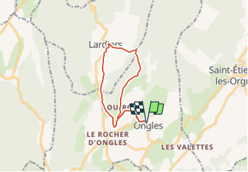
Entre Ongles et Lardiers depart Ongles 276 +

claude nier
User

Length
11.6 km

Max alt
843 m

Uphill gradient
276 m
Km-Effort
15.3 km

Min alt
619 m

Downhill gradient
276 m
Boucle
Yes
Creation date :
2022-04-02 11:58:35.81
Updated on :
2022-04-02 11:59:39.939
3h28
Difficulty : Difficult

FREE GPS app for hiking
 SityTrail
IGN / Geographical institutes
SityTrail Plus
The world is yours!
About
Trail Walking of 11.6 km to be discovered at Provence-Alpes-Côte d'Azur, Alpes-de-Haute-Provence, Ongles. This trail is proposed by claude nier.
Description
petite rando sympa
Positioning
Country:
France
Region :
Provence-Alpes-Côte d'Azur
Department/Province :
Alpes-de-Haute-Provence
Municipality :
Ongles
Location:
Unknown
Start:(Dec)
Start:(UTM)
719013 ; 4878628 (31T) N.
Comments