


Puget Thénier - Entrevaux

soca
User
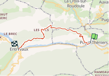

Length
11.9 km

Max alt
1018 m

Uphill gradient
799 m
Km-Effort
22 km

Min alt
405 m

Downhill gradient
719 m
Boucle
No
Creation date :
2022-04-02 13:40:28.51
Updated on :
2022-04-02 13:49:18.204
5h30
Difficulty : Difficult

FREE GPS app for hiking
 SityTrail
IGN / Geographical institutes
SityTrail Plus
The world is yours!
About
Trail Walking of 11.9 km to be discovered at Provence-Alpes-Côte d'Azur, Maritime Alps, Puget-Théniers. This trail is proposed by soca.
Positioning
Country:
France
Region :
Provence-Alpes-Côte d'Azur
Department/Province :
Maritime Alps
Municipality :
Puget-Théniers
Location:
Unknown
Start:(Dec)
Start:(UTM)
330809 ; 4869007 (32T) N.
Comments