


beignon

nikter
User
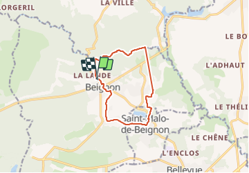

Length
10 km

Max alt
127 m

Uphill gradient
151 m
Km-Effort
12.1 km

Min alt
67 m

Downhill gradient
150 m
Boucle
Yes
Creation date :
2022-04-02 13:06:25.449
Updated on :
2022-04-02 15:54:11.371
2h06
Difficulty : Difficult

FREE GPS app for hiking
 SityTrail
IGN / Geographical institutes
SityTrail Plus
The world is yours!
About
Trail Walking of 10 km to be discovered at Brittany, Morbihan, Beignon. This trail is proposed by nikter.
Positioning
Country:
France
Region :
Brittany
Department/Province :
Morbihan
Municipality :
Beignon
Location:
Unknown
Start:(Dec)
Start:(UTM)
561600 ; 5313647 (30T) N.
Comments