


OR-4497264--Chalencon:PONT CHERVIL CHALENCON

TOULAUDIN
User
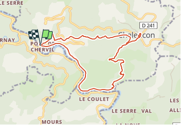

Length
9.8 km

Max alt
708 m

Uphill gradient
466 m
Km-Effort
16 km

Min alt
276 m

Downhill gradient
463 m
Boucle
Yes
Creation date :
2022-04-03 08:31:28.302
Updated on :
2022-04-03 08:34:45.217
3h38
Difficulty : Easy

FREE GPS app for hiking
 SityTrail
IGN / Geographical institutes
SityTrail Plus
The world is yours!
About
Trail Walking of 9.8 km to be discovered at Auvergne-Rhône-Alpes, Ardèche, Chalencon. This trail is proposed by TOULAUDIN.
Positioning
Country:
France
Region :
Auvergne-Rhône-Alpes
Department/Province :
Ardèche
Municipality :
Chalencon
Location:
Unknown
Start:(Dec)
Start:(UTM)
621637 ; 4970191 (31T) N.
Comments