


X rousse Fourrière

Mariolebeno
User
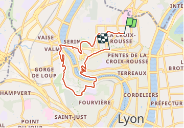

Length
7.5 km

Max alt
290 m

Uphill gradient
226 m
Km-Effort
10.5 km

Min alt
165 m

Downhill gradient
228 m
Boucle
No
Creation date :
2022-04-03 09:01:41.966
Updated on :
2022-04-03 10:07:12.843
54m
Difficulty : Very easy

FREE GPS app for hiking
 SityTrail
IGN / Geographical institutes
SityTrail Plus
The world is yours!
About
Trail Running of 7.5 km to be discovered at Auvergne-Rhône-Alpes, Métropole de Lyon, Lyon. This trail is proposed by Mariolebeno.
Positioning
Country:
France
Region :
Auvergne-Rhône-Alpes
Department/Province :
Métropole de Lyon
Municipality :
Lyon
Location:
Lyon 4e Arrondissement
Start:(Dec)
Start:(UTM)
642264 ; 5070963 (31T) N.
Comments