


Tour pic st loup /tour ruinée et /montée au sommet en solo

BERNADETTE MONEY
User
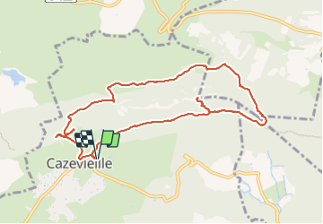

Length
11.1 km

Max alt
645 m

Uphill gradient
619 m
Km-Effort
19.3 km

Min alt
222 m

Downhill gradient
618 m
Boucle
Yes
Creation date :
2022-04-03 08:47:49.578
Updated on :
2022-04-03 13:07:56.827
3h51
Difficulty : Medium

FREE GPS app for hiking
 SityTrail
IGN / Geographical institutes
SityTrail Plus
The world is yours!
About
Trail Walking of 11.1 km to be discovered at Occitania, Hérault, Cazevieille. This trail is proposed by BERNADETTE MONEY.
Positioning
Country:
France
Region :
Occitania
Department/Province :
Hérault
Municipality :
Cazevieille
Location:
Unknown
Start:(Dec)
Start:(UTM)
563769 ; 4846699 (31T) N.
Comments