


Rando challenge juin 2022 soit 7 kms pour 165 +

claude nier
User
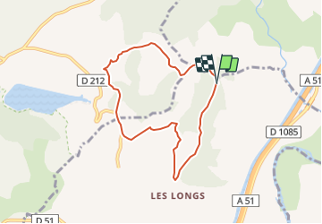

Length
7.1 km

Max alt
734 m

Uphill gradient
165 m
Km-Effort
9.3 km

Min alt
642 m

Downhill gradient
165 m
Boucle
Yes
Creation date :
2022-04-03 13:55:12.871
Updated on :
2022-04-03 13:56:15.227
2h06
Difficulty : Medium

FREE GPS app for hiking
 SityTrail
IGN / Geographical institutes
SityTrail Plus
The world is yours!
About
Trail Walking of 7.1 km to be discovered at Provence-Alpes-Côte d'Azur, Hautes-Alpes, Upaix. This trail is proposed by claude nier.
Description
boucle des 7 kms
Positioning
Country:
France
Region :
Provence-Alpes-Côte d'Azur
Department/Province :
Hautes-Alpes
Municipality :
Upaix
Location:
Unknown
Start:(Dec)
Start:(UTM)
730473 ; 4914624 (31T) N.
Comments