


rando Toulouse

evelyne10
User

Length
353 m

Max alt
153 m

Uphill gradient
2 m
Km-Effort
403 m

Min alt
140 m

Downhill gradient
9 m
Boucle
No
Creation date :
2022-04-03 15:22:19.6
Updated on :
2022-04-03 16:24:04.119
35m
Difficulty : Easy

FREE GPS app for hiking
 SityTrail
IGN / Geographical institutes
SityTrail Plus
The world is yours!
About
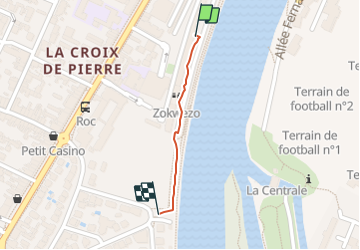
Trail Walking of 353 m to be discovered at Occitania, Haute-Garonne, Toulouse. This trail is proposed by evelyne10.
Description
le long de la Garonne
Positioning
Country:
France
Region :
Occitania
Department/Province :
Haute-Garonne
Municipality :
Toulouse
Location:
Unknown
Start:(Dec)
Start:(UTM)
373073 ; 4826726 (31T) N.
Comments