


teldruc yrez,_bellec

elianette
User

Length
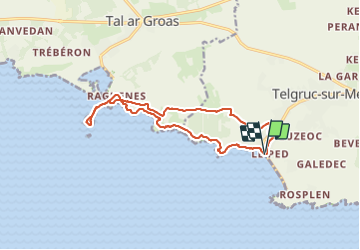
13.6 km

Max alt
115 m

Uphill gradient
303 m
Km-Effort
17.6 km

Min alt
0 m

Downhill gradient
306 m
Boucle
Yes
Creation date :
2022-04-04 12:05:41.345
Updated on :
2022-04-04 15:32:17.237
3h05
Difficulty : Very easy

FREE GPS app for hiking
 SityTrail
IGN / Geographical institutes
SityTrail Plus
The world is yours!
About
Trail Nordic walking of 13.6 km to be discovered at Brittany, Finistère, Telgruc-sur-Mer. This trail is proposed by elianette.
Description
randonnée moyenne
Photos


Positioning
Country:
France
Region :
Brittany
Department/Province :
Finistère
Municipality :
Telgruc-sur-Mer
Location:
Unknown
Start:(Dec)
Start:(UTM)
397777 ; 5341461 (30U) N.
Comments