


guilhomard vtt

lablaquiere
User
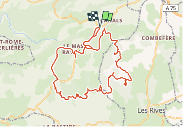

Length
28 km

Max alt
826 m

Uphill gradient
497 m
Km-Effort
34 km

Min alt
720 m

Downhill gradient
498 m
Boucle
Yes
Creation date :
2022-04-04 12:45:56.691
Updated on :
2022-04-04 16:44:40.541
3h05
Difficulty : Difficult

FREE GPS app for hiking
 SityTrail
IGN / Geographical institutes
SityTrail Plus
The world is yours!
About
Trail Mountain bike of 28 km to be discovered at Occitania, Aveyron, Cornus. This trail is proposed by lablaquiere.
Positioning
Country:
France
Region :
Occitania
Department/Province :
Aveyron
Municipality :
Cornus
Location:
Unknown
Start:(Dec)
Start:(UTM)
518906 ; 4858887 (31T) N.
Comments