


Le prieuré St Martin, la fage

JMJ42
User
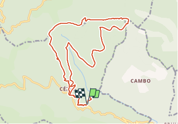

Length
12.6 km

Max alt
925 m

Uphill gradient
533 m
Km-Effort
19.7 km

Min alt
536 m

Downhill gradient
533 m
Boucle
Yes
Creation date :
2022-04-05 07:44:47.763
Updated on :
2022-04-05 13:43:57.795
3h29
Difficulty : Medium

FREE GPS app for hiking
 SityTrail
IGN / Geographical institutes
SityTrail Plus
The world is yours!
About
Trail Walking of 12.6 km to be discovered at Occitania, Gard, Sumène. This trail is proposed by JMJ42.
Positioning
Country:
France
Region :
Occitania
Department/Province :
Gard
Municipality :
Sumène
Location:
Unknown
Start:(Dec)
Start:(UTM)
562948 ; 4869172 (31T) N.
Comments