


Garlaban par les 4 fers

ARPF
User
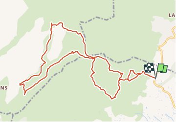

Length
14.1 km

Max alt
682 m

Uphill gradient
933 m
Km-Effort
27 km

Min alt
223 m

Downhill gradient
933 m
Boucle
Yes
Creation date :
2022-04-05 18:00:01.547
Updated on :
2022-04-05 18:08:17.116
6h02
Difficulty : Very difficult

FREE GPS app for hiking
 SityTrail
IGN / Geographical institutes
SityTrail Plus
The world is yours!
About
Trail Walking of 14.1 km to be discovered at Provence-Alpes-Côte d'Azur, Bouches-du-Rhône, Aubagne. This trail is proposed by ARPF.

Positioning
Country:
France
Region :
Provence-Alpes-Côte d'Azur
Department/Province :
Bouches-du-Rhône
Municipality :
Aubagne
Location:
Unknown
Start:(Dec)
Start:(UTM)
708599 ; 4800663 (31T) N.
Comments