


84 Fontaine de Vaucluse C1

HAL26
User
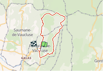

Length
15.2 km

Max alt
663 m

Uphill gradient
655 m
Km-Effort
24 km

Min alt
79 m

Downhill gradient
658 m
Boucle
No
Creation date :
2022-04-06 07:19:39.735
Updated on :
2022-04-06 12:41:10.213
4h11
Difficulty : Medium

FREE GPS app for hiking
 SityTrail
IGN / Geographical institutes
SityTrail Plus
The world is yours!
About
Trail Walking of 15.2 km to be discovered at Provence-Alpes-Côte d'Azur, Vaucluse, Fontaine-de-Vaucluse. This trail is proposed by HAL26.
Positioning
Country:
France
Region :
Provence-Alpes-Côte d'Azur
Department/Province :
Vaucluse
Municipality :
Fontaine-de-Vaucluse
Location:
Unknown
Start:(Dec)
Start:(UTM)
670819 ; 4865168 (31T) N.
Comments