


roco bouverie

ninia
User
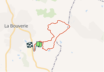

Length
6.8 km

Max alt
97 m

Uphill gradient
104 m
Km-Effort
8.2 km

Min alt
40 m

Downhill gradient
107 m
Boucle
Yes
Creation date :
2022-04-07 06:44:42.023
Updated on :
2022-04-07 08:56:23.779
2h11
Difficulty : Very easy

FREE GPS app for hiking
 SityTrail
IGN / Geographical institutes
SityTrail Plus
The world is yours!
About
Trail Walking of 6.8 km to be discovered at Provence-Alpes-Côte d'Azur, Var, Roquebrune-sur-Argens. This trail is proposed by ninia.
Positioning
Country:
France
Region :
Provence-Alpes-Côte d'Azur
Department/Province :
Var
Municipality :
Roquebrune-sur-Argens
Location:
Unknown
Start:(Dec)
Start:(UTM)
310433 ; 4817909 (32T) N.
Comments