


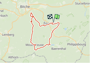
2022-04-09 WE CVA Eguelshardt Etangs

holtzv
User GUIDE

Length
29 km

Max alt
397 m

Uphill gradient
751 m
Km-Effort
39 km

Min alt
209 m

Downhill gradient
749 m
Boucle
Yes
Creation date :
2022-04-09 07:33:28.331
Updated on :
2022-04-11 08:34:44.819
5h09
Difficulty : Difficult

FREE GPS app for hiking
 SityTrail
IGN / Geographical institutes
SityTrail Plus
The world is yours!
About
Trail Horseback riding of 29 km to be discovered at Grand Est, Moselle, Éguelshardt. This trail is proposed by holtzv.
Description
Pause déjeuner à Mouterhouse
Etang de Hasselfurth
Etang d'Entenbaechel
Grand Etang de Mouterhouse
Etang de Baerenthal
Positioning
Country:
France
Region :
Grand Est
Department/Province :
Moselle
Municipality :
Éguelshardt
Location:
Unknown
Start:(Dec)
Start:(UTM)
390629 ; 5431026 (32U) N.
Comments