


![Trail On foot Saint-Étienne-de-Tinée - Randonnée 1 : Mont Mounier en boucle (Retour par l'Arête Nord et la Crête de Colombet) depuis Roya [ https://www.toujoursplushaut06.fr/Description/Mont-Mounier ] - Photo](https://media.geolcdn.com/t/1900/400/ext.pjpeg?maxdim=2&url=https%3A%2F%2Fstatic1.geolcdn.com%2Fsiteimages%2Fupload%2Ffiles%2F1545311037marcheuse_200dpi.jpg)
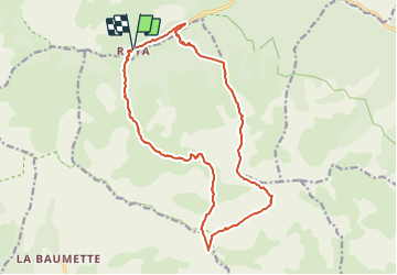
Randonnée 1 : Mont Mounier en boucle (Retour par l'Arête Nord et la Crête de Colombet) depuis Roya [ https://www.toujoursplushaut06.fr/Description/Mont-Mounier ]

ETMU5496
User

Length
18.3 km

Max alt
2791 m

Uphill gradient
1490 m
Km-Effort
38 km

Min alt
1385 m

Downhill gradient
1500 m
Boucle
Yes
Creation date :
2022-04-09 15:51:01.737
Updated on :
2022-04-09 15:55:28.512
8h41
Difficulty : Very difficult

FREE GPS app for hiking
 SityTrail
IGN / Geographical institutes
SityTrail Plus
The world is yours!
About
Trail On foot of 18.3 km to be discovered at Provence-Alpes-Côte d'Azur, Maritime Alps, Saint-Étienne-de-Tinée. This trail is proposed by ETMU5496.
Description
Retour par l'Arête Nord et la Crête de Colombet depuis Roya
Points of interest


Positioning
Country:
France
Region :
Provence-Alpes-Côte d'Azur
Department/Province :
Maritime Alps
Municipality :
Saint-Étienne-de-Tinée
Location:
Unknown
Start:(Dec)
Start:(UTM)
334509 ; 4894992 (32T) N.
Comments