


Marsanne4

parastat
User
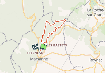

Length
11.9 km

Max alt
538 m

Uphill gradient
389 m
Km-Effort
17.1 km

Min alt
337 m

Downhill gradient
389 m
Boucle
Yes
Creation date :
2022-04-09 18:01:03.228
Updated on :
2022-05-28 15:41:24.687
3h53
Difficulty : Difficult

FREE GPS app for hiking
 SityTrail
IGN / Geographical institutes
SityTrail Plus
The world is yours!
About
Trail Walking of 11.9 km to be discovered at Auvergne-Rhône-Alpes, Drôme, Marsanne. This trail is proposed by parastat.
Positioning
Country:
France
Region :
Auvergne-Rhône-Alpes
Department/Province :
Drôme
Municipality :
Marsanne
Location:
Unknown
Start:(Dec)
Start:(UTM)
648598 ; 4945572 (31T) N.
Comments