


soing en sologne

lecmic
User
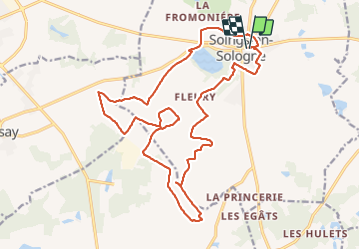

Length
23 km

Max alt
137 m

Uphill gradient
172 m
Km-Effort
25 km

Min alt
100 m

Downhill gradient
173 m
Boucle
Yes
Creation date :
2022-04-10 05:00:52.196
Updated on :
2022-04-10 09:06:17.562
3h54
Difficulty : Easy

FREE GPS app for hiking
 SityTrail
IGN / Geographical institutes
SityTrail Plus
The world is yours!
About
Trail Walking of 23 km to be discovered at Centre-Loire Valley, Loir-et-Cher, Soings-en-Sologne. This trail is proposed by lecmic.
Description
les vignes
Positioning
Country:
France
Region :
Centre-Loire Valley
Department/Province :
Loir-et-Cher
Municipality :
Soings-en-Sologne
Location:
Unknown
Start:(Dec)
Start:(UTM)
388914 ; 5252097 (31T) N.
Comments