


Givry -jambles

XavierFaidix
User
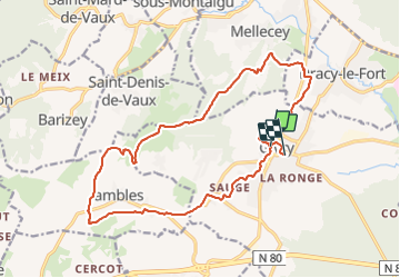

Length
18.4 km

Max alt
444 m

Uphill gradient
379 m
Km-Effort
23 km

Min alt
212 m

Downhill gradient
385 m
Boucle
No
Creation date :
2022-04-10 07:06:21.491
Updated on :
2022-04-10 12:06:03.52
2h30
Difficulty : Medium

FREE GPS app for hiking
 SityTrail
IGN / Geographical institutes
SityTrail Plus
The world is yours!
About
Trail Mountain bike of 18.4 km to be discovered at Bourgogne-Franche-Comté, Saône-et-Loire, Givry. This trail is proposed by XavierFaidix.
Positioning
Country:
France
Region :
Bourgogne-Franche-Comté
Department/Province :
Saône-et-Loire
Municipality :
Givry
Location:
Unknown
Start:(Dec)
Start:(UTM)
632900 ; 5182566 (31T) N.
Comments