


Lardy

verozerr
User

Length
11 km

Max alt
154 m

Uphill gradient
193 m
Km-Effort
13.6 km

Min alt
55 m

Downhill gradient
181 m
Boucle
No
Creation date :
2022-04-10 10:08:44.576
Updated on :
2022-05-08 21:11:52.713
4h07
Difficulty : Medium

FREE GPS app for hiking
 SityTrail
IGN / Geographical institutes
SityTrail Plus
The world is yours!
About
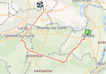
Trail Walking of 11 km to be discovered at Ile-de-France, Essonne, Itteville. This trail is proposed by verozerr.
Description
Lardy 10042023
Positioning
Country:
France
Region :
Ile-de-France
Department/Province :
Essonne
Municipality :
Itteville
Location:
Unknown
Start:(Dec)
Start:(UTM)
451034 ; 5373425 (31U) N.
Comments