


couches

mcterret
User

Length
18.1 km

Max alt
450 m

Uphill gradient
415 m
Km-Effort
24 km

Min alt
250 m

Downhill gradient
400 m
Boucle
No
Creation date :
2022-04-10 08:29:42.246
Updated on :
2022-04-10 14:56:56.382
4h19
Difficulty : Easy

FREE GPS app for hiking
 SityTrail
IGN / Geographical institutes
SityTrail Plus
The world is yours!
About
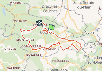
Trail Walking of 18.1 km to be discovered at Bourgogne-Franche-Comté, Saône-et-Loire, Couches. This trail is proposed by mcterret.
Positioning
Country:
France
Region :
Bourgogne-Franche-Comté
Department/Province :
Saône-et-Loire
Municipality :
Couches
Location:
Unknown
Start:(Dec)
Start:(UTM)
619953 ; 5191674 (31T) N.
Comments