


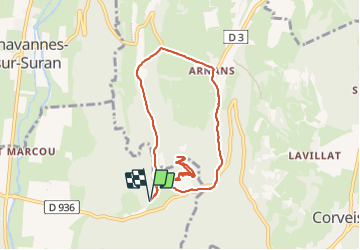
Selignac Arnans

HB01
User

Length
8.4 km

Max alt
577 m

Uphill gradient
387 m
Km-Effort
13.6 km

Min alt
375 m

Downhill gradient
388 m
Boucle
Yes
Creation date :
2022-04-10 11:09:50.497
Updated on :
2022-04-10 14:58:22.771
2h29
Difficulty : Medium

FREE GPS app for hiking
 SityTrail
IGN / Geographical institutes
SityTrail Plus
The world is yours!
About
Trail Walking of 8.4 km to be discovered at Auvergne-Rhône-Alpes, Ain, Simandre-sur-Suran. This trail is proposed by HB01.
Description
Départ de la Chartreuse
Positioning
Country:
France
Region :
Auvergne-Rhône-Alpes
Department/Province :
Ain
Municipality :
Simandre-sur-Suran
Location:
Unknown
Start:(Dec)
Start:(UTM)
688724 ; 5124284 (31T) N.
Comments